EADP19-001 Esri ArcGIS Desktop Professional 19-001 Free Practice Exam Questions (2026 Updated)
Prepare effectively for your Esri EADP19-001 ArcGIS Desktop Professional 19-001 certification with our extensive collection of free, high-quality practice questions. Each question is designed to mirror the actual exam format and objectives, complete with comprehensive answers and detailed explanations. Our materials are regularly updated for 2026, ensuring you have the most current resources to build confidence and succeed on your first attempt.
An ArcGIS has created a definition query on a parcel feature in a personal geodatabase to only show areas classified as residential. The user's company has decided to update all personal geodatabase to file geodatabases.
When the ArcGIS user updates the source data to point to the parcel feature class in the file geodatabase they receive the following error.
"One or more layers failed to draw:
Parcel: An invalid SQL statement was used. [Select Shape FROM Parcel WHERE [Parcel] B residential]
Parcel: An invalid SQL statement was used"
What is the correct SQL statement for the file geodatabase?
An ArcGlS user has a point feature class and needs to determine whether there are anyspatial outliers. For this project, a spatial outlier is defined as any feature that is greater than one standard deviation from the mean center of the features.
Which Spatial Statistics geoprocessing tool should be used to accomplish this task?
A layer tiding simple symbology is causing slow drawing performance at a scale where analysis needs to be conducted. Only certain features from this layer are necessary in order for analysis to be completed by the ArcGlS user
What can the user do to increase drawing performance?
A taster contains pixels with decimal values.
Which method is used to round raster pixel values to the nearest whole number?
Refer to the exhibit.
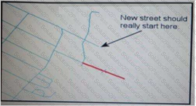
An ArcGIS user added a new street (shown in the exhibit) to a streets feature class within an edit session.
The new street seems to have snapped to an existing street but upon zooming in the ArcGIS user notices that the street is connected to the wrong street.
What is the most likely reason for this error?
A Microstation.dgn file is created for a mountainous area and is added to ArcMap with another vector dataset in the same projection. The .dgn file appears slightly too large in relation to the other data.
What is the most likely source of the problem?
An ArcGlS user maintains a street signpost database with measure in terms of two route feature classes: distance from the nearest school and distance along the street.
If the two feature classes are created from the same source line feature class, which geoprocessing tool will support calculating one event from the other?
An ArcGIS user is tasked with converting an IDRISI vector format file to a geodatabase feature class. The user does not need to change any aspects of the data source in the output feature class.
Which tool should the user employ?
An ArcGIS user is writing a Python script that will update the geometry of all the features of an input layer using a process that requires system tools to examine the geometric properties of each feature.
Which approach should be used to evaluate each feature's geometry and pass it to a system tool?
A raster dataset called rasterl.tif contains many pixels with values of NoData.
Which map algebra expression changes NoData values to 0 (zero) in the output raster dataset while leaving all other pixel values the same?
An ArcGlS user receives two shapefiles that are defined with the same projection and represent features in the same study area. When they are displayed together in ArcMap. the difference of their locations in coordinate space is so large that they are barely visible when viewed at their full extent.
How can the user determine whether the projections of the shapefiles are correctly defined?
An ArcGIS user wants to make a map displaying the data using an equal number of features in each classification. Which classification method should the user employ to accomplish this?
An ArcGIS user is creating a processing environment that will be used repeatedly. To confirm results, the user wants to visualize the output of Intermediate processes during testing. The user is working with large data sets and wants to preserve already-complete steps and focus on one problem at a time.
Which geoprocessing approach should the user consider?
An ArcGlS user receives parcel data from the regional government, which is supposed to line up with parcels in the data maintained by the local government. The user is tasked with reconciling the discrepancies between the local and regional data.
In which situation are the parcel boundaries within the local data more likely to be accurate than the regional data?
The ArcGIS user is given data for the Arctic and is asked to perform various types of analysis using the data. The data extends from the North Pole south to 70 degrees North Latitude Data layers may contain points lines, or polygons, and include ice surveys from NOAA depth contours: continental margins, locations of known and suspected oil reserves, endangered species habitat, and territorial boundaries for nations having Arctic coastline.
Which map projection should be used for the data to allow the most accurate buffering of those areas, in order to comply with the U.S court decision that ships may not approach closer than 20 nautical miles to a seal rookery?
In the Feature Class to Feature Class tool which parameter allows an ArcGlS user to manipulate attributes to be included the output feature class table?
Refer to the exhibits.
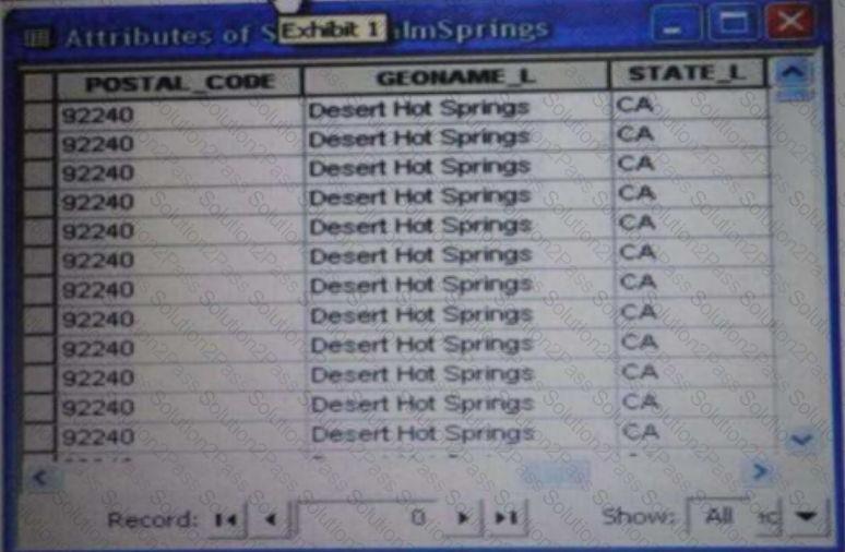
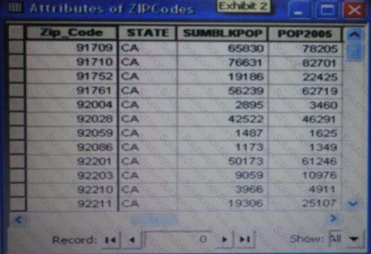
An ArcGIS user is attempting to create a relationship class between the two tables shown in the exhibit using POSTAL_CODE and Zip Code as the origin primary key and destination foreign Keys, respectively. However when the user tries to set the keys zip Cede does not appear in the drop-down list of candidate keys
What should the user do to successfully create the relationship class?
An ArcGIS user wants to create a tool that reads a Web data source from the U.S. Geological Survey site and create a feature class of earthquakes over magnitude 1 that have occurred in the last seven days. The data source URL is a .txt file directly usable as x, v event data, once downloaded.
The goal is to have a repeatable process to be run on demand overwriting the output each time with minimal user input and easy to understand for other users to whom the tool is provided
What should the user do to read and process the data?
An ArcGlS administrator is creating a custom toolbar containing tools commonly used throughout the administrator's organization. The tools include browsing, querying, and editing tools. All tools will be located on a single custom toolbar.
How can this custom toolbar be designed to maximize efficiency?
An ArcGIS user is given a geodatabase containing polygon and point features.
To ensure that the points fall on the boundary, which topology rule should the user set?